MeasurementSite
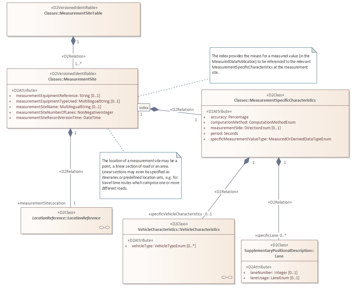
The measurementSiteTable consists of one or more measurementSite elements. These contain the actual measurement configurations and location references. This page focuses on the description of the measurement configuration. More information on location referencing of measurement points and measurement zones can be found in the documentation on Location Reference.
The structure, including the overarching measurementSiteTable, is as follows:
Attributes
| Attribute | Type | Mandatory | Domain | Description |
|---|---|---|---|---|
| id | String | Yes | See explanation | A unique identifier for the measurement site |
| version | String | Yes | >=1 See explanation | Applicable version of the measurement site |
id
The id attribute assigns a name (identifier) to a measurement site. This measurement site typically retains the same id throughout its lifecycle. If the properties of a measurement site change significantly, a new record (and thus a new id) is created for the site. This occurs, for example, when:
- Different data types are added;
- The number of lanes and/or categories changes;
- The location moves more than 50 meters;
- Other changes occur that make it undesirable to continue using the same id.
Explanation of measurementSite.id
In the Dutch DATEX II profile, it is agreed that the name starts with the value of measurementSiteTable.id, followed by an ‘_’ and then a value assigned by the data provider.
version
Any change in the content of the measurementSite element (the properties of a measurement site) results in a new version of that measurement site. This means the version attribute is incremented by 1 and the timestamp in the measurementSiteRecordVersionTime element is updated.
Elements
| Element | Type | Mandatory | Domain | Description |
|---|---|---|---|---|
| measurementSiteRecordVersionTime | DateTime | Yes | Date and time in UTC (Zulu notation) | When the measurementSite.version attribute is adjusted (incremented), the measurementSiteRecordVersionTime element is adjusted accordingly |
| measurementEquipmentReference | String | No | N/A | In this element, the data provider can indicate the type of equipment used for the measurement site with a reference |
| measurementEquipmentTypeUsed | MultilingualString | No | See explanation | This element specifies the type of equipment the measurement site is equipped with |
| measurementSiteName | MultilingualString | No | N/A | This element provides a readable name for the measurement site. However, it should not be used as a method of location referencing |
| measurementSiteNumberOfLanes | NonNegativeInteger | Yes | >=0 | This element describes the total number of lanes from which the measurement site provides values |
| measurementSpecificCharacteristics | MeasurementSpecificCharacteristics | Yes | N/A | The measurementSpecificCharacteristics element occurs once or more per measurement site and describes a measurement point-data type-vehicle category trio |
| measurementSiteLocation | LocationReference | Yes | N/A | The exact location of the measurement site is described in the measurementSiteLocation element, which is a specification of the base class LocationReference. The exact type is indicated using the xsi:type attribute |
Subelement measurementEquipmentTypeUsed
This element indicates the type of equipment used at the measurement site.
| Domain value | Explanation |
|---|---|
| anpr | License plate recognition |
| bluetooth | Bluetooth equipment passages |
| fcd | Floating car data |
| infrared | Infrared detection |
| laser | Laser detection |
| loop | Detection using loops in the roadway |
| microwave | Microwave detection |
| radar | Radar detection |
| telslang | Detection or counting using induction loops |
| video detection | Video detection (except license plate recognition) |
| vri | Traffic signal installation |
| data fusion | Combination of collection techniques, where data is fused |
| other | Any other form of detection or a combination of techniques |
XML Example
<roa:measurementSite id="PZH01_MST_0080_01" version="3">
    <roa:measurementSiteRecordVersionTime>2021-12-17T09:30:47Z</roa:measurementSiteRecordVersionTime>
    <roa:measurementEquipmentReference>0080_01</roa:measurementEquipmentReference>
    <roa:measurementEquipmentTypeUsed>
        <com:values>
            <com:value lang="nl-nl">lus</com:value>
        </com:values>
    </roa:measurementEquipmentTypeUsed>
    <roa:measurementSiteName>
        <com:values>
            <com:value lang="nl-nl">N210 km 17.801</com:value>
        </com:values>
    </roa:measurementSiteName>
    <roa:measurementSiteNumberOfLanes>1</roa:measurementSiteNumberOfLanes>
    <roa:measurementSpecificCharacteristics index="0">
        <roa:measurementSpecificCharacteristics>
            <roa:accuracy>95</roa:accuracy>
            <roa:computationMethod>arithmeticAverageOfSamplesInATimePeriod</roa:computationMethod>
            <roa:measurementSide>southWestBound</roa:measurementSide>
            <roa:period>60</roa:period>
            <roa:specificMeasurementValueType>trafficFlow</roa:specificMeasurementValueType>
            <roa:specificVehicleCharacteristics>
                <com:lengthCharacteristic>
                    <com:comparisonOperator>lessThan</com:comparisonOperator>
                    <com:vehicleLength>5.6</com:vehicleLength>
                </com:lengthCharacteristic>
            </roa:specificVehicleCharacteristics>
            <roa:specificLane>
                <loc:laneNumber>1</loc:laneNumber>
            </roa:specificLane>
        </roa:measurementSpecificCharacteristics>
    </roa:measurementSpecificCharacteristics>
    ...
    <roa:measurementSiteLocation xsi:type="loc:PointLocation">
    ...
    </roa:measurementSiteLocation>
</roa:measurementSite>