LocationCondition
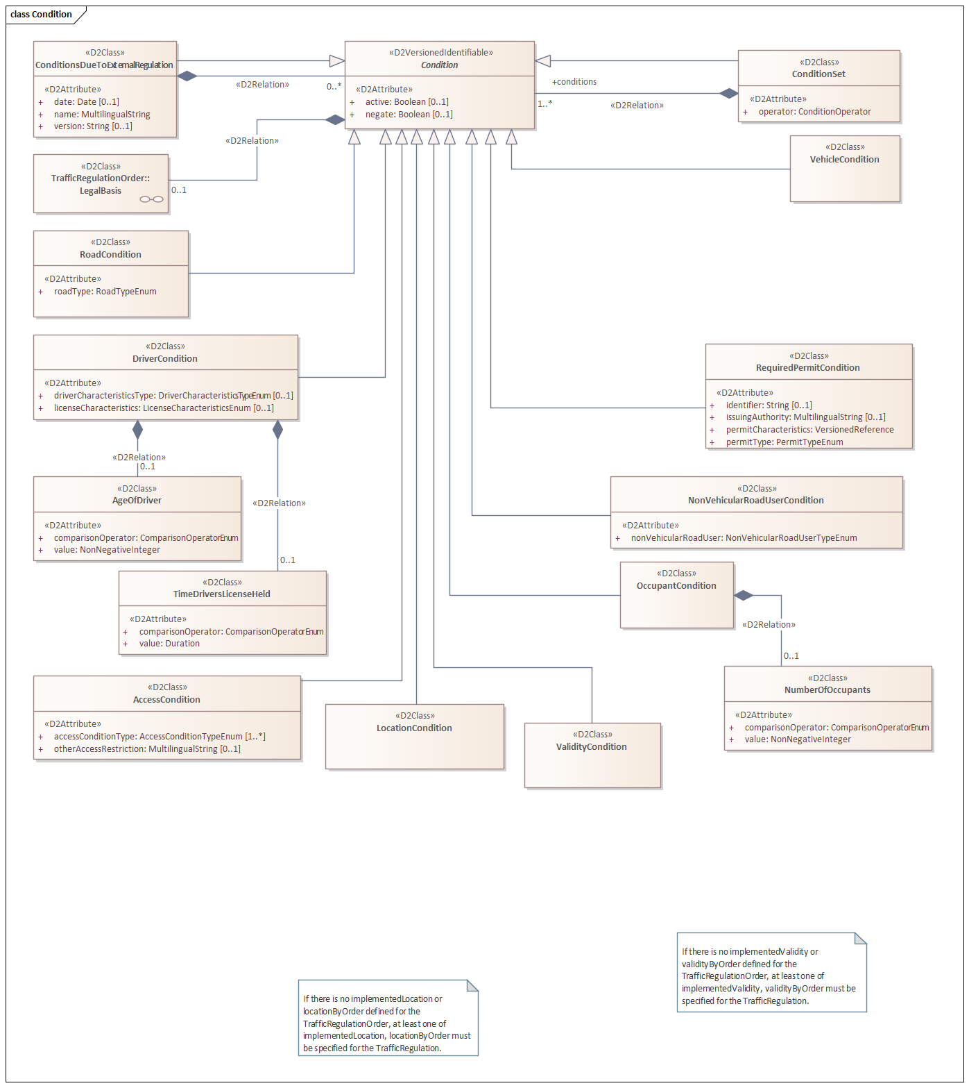
A LocationCondition is used to define conditions that specifically relate to a location within a controlled zone.
The purpose of a LocationCondition is to indicate which part of the controlled zone certain rules or restrictions apply to. This allows regulations to be refined to specific geographic areas, such as streets, neighborhoods, or sections of a zone.
Applications:
- Subzones: Define different rules in separate parts of a zone, such as a core area with stricter access requirements within a larger environmental zone.
- Delimited locations: Rules that only apply to specific locations, such as a loading/unloading zone or a parking area.
- Border areas: Specify conditions applicable in transition zones, such as areas where a lower speed limit starts.
By using LocationCondition, the application of rules can be precisely tailored to specific areas within a controlled zone. This makes the management and communication of complex rule sets more efficient and clearer for users and systems.
Structure:
Elements
The LocationCondition type is derived from Condition and introduces the new mandatory element locationByOrder.
| Element | Type | Mandatory | Domain | Description |
|---|---|---|---|---|
| locationByOrder | LocationReference | Yes | N/A | The ordered (planned) location as defined in the original traffic regulation decision, if available |
XML Example
<d2:payload xmlns:tro="http://datex2.eu/schema/3/trafficRegulation" xmlns:loc="http://datex2.eu/schema/3/locationReferencing" xmlns:cz="http://datex2.eu/schema/3/controlledZone" xmlns:comx="http://datex2.eu/schema/3/commonExtension" xmlns:com="http://datex2.eu/schema/3/common" xmlns:d2="http://datex2.eu/schema/3/d2Payload" xmlns:xsi="http://www.w3.org/2001/XMLSchema-instance" xsi:type="cz:ControlledZoneTablePublication" lang="nl" modelBaseVersion="3" xsi:schemaLocation="http://datex2.eu/schema/3/d2Payload LevelC_3_D2Payload.xsd">
  <com:publicationTime>2024-11-13T09:00:50.000356907Z</com:publicationTime>
  <com:publicationCreator>
    <com:country>nl</com:country>
    <com:nationalIdentifier>NDWNL</com:nationalIdentifier>
  </com:publicationCreator>
  <cz:headerInformation>
    <com:informationStatus>real</com:informationStatus>
  </cz:headerInformation>
  <cz:controlledZoneTable>
      ...
      <cz:trafficRegulationOrder id="NDW11_989846cf-0343-4abc-b169-1a2ddaf497d9_TRO" version="1">
        ...
        <tro:trafficRegulation id="NDW11_989846cf-0343-4abc-b169-1a2ddaf497d9_TR" version="1">
            <tro:typeOfRegulation xsi:type="tro:AccessRestriction">
                <tro:accessRestrictionType>noEntry</tro:accessRestrictionType>
            </tro:typeOfRegulation>
            <tro:condition xsi:type="tro:ConditionSet" id="NDW11_989846cf-0343-4abc-b169-1a2ddaf497d9_CS" version="1">
            <tro:operator>and</tro:operator>
            <tro:conditions xsi:type="tro:ValidityCondition" id="NDW11_989846cf-0343-4abc-b169-1a2ddaf497d9_VC" version="1">
              <tro:validityByOrder>
                ...
              </tro:validityByOrder>
            </tro:conditions>
            <tro:conditions xsi:type="tro:LocationCondition" id="NDW11_989846cf-0343-4abc-b169-1a2ddaf497d9_area" version="1">
              <tro:locationByOrder xsi:type="loc:AreaLocation">
                <loc:gmlMultiPolygon>
                  <loc:gmlPolygon>
                    <loc:exterior srsName="WGS 84">
                      <loc:posList>4.849957 52.399986 4.850217 52.400117 4.851841 52.39934</loc:posList>
                    </loc:exterior>
                  </loc:gmlPolygon>
                </loc:gmlMultiPolygon>
              </tro:locationByOrder>
            </tro:conditions>
           </tro:conditions>
        </tro:trafficRegulation>
      </cz:trafficRegulationOrder>
    </cz:urbanVehicleAccessRegulation>
    <cz:urbanVehicleAccessRegulation id="NDW11_500de66b-b51e-465f-8309-6d5eda0de5a1" version="1">
        ..
    </cz:urbanVehicleAccessRegulation>
  </cz:controlledZoneTable>
</d2:payload>