Partial Closure - Specialization RoadOrCarriagewayOrLaneManagement within profile Planned Roadworks & Events Feed
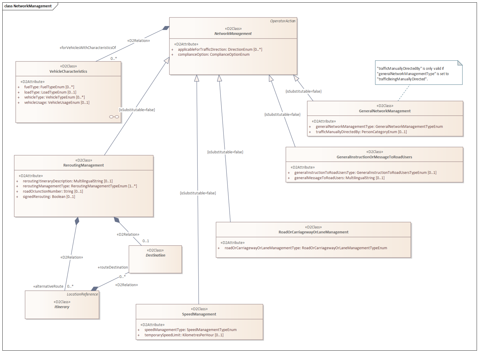
The type RoadOrCarriagewayOrLaneManagement is derived from NetworkManagement with the specialization SituationRecord above it being OperatorAction. RoadOrCarriagewayOrLaneManagement is used to describe restrictions or openings of lanes or roads. In addition to the basic elements of a SituationRecord, specific elements of OperatorAction and NetworkManagement, additional information about the restriction or opening is included in an extra mandatory data element.
The structure is as follows (shortened representation of included elements from NetworkManagement):
This specialization provides characterizations regarding a restriction or opening of lanes or roads. This includes information such as: narrowed lane, night closure, road closed, etc. The various options can be found in the possible domain values of the element roadOrCarriagewayOrLaneManagementType.
Elements
An overview of elements that occur in each specialization of a SituationRecord can be found here. In the case of the specialization RoadOrCarriagewayOrLaneManagement, these elements are supplemented with the elements of the specializations OperatorAction, NetworkManagement, and RoadOrCarriagewayOrLaneManagement itself.
Explanation of operatorActionStatus
The element operatorActionStatus is used to indicate the status of an operator-driven dynamic traffic situation. It pertains to a status indication regarding information about objects. In this example the application is explained in more detail.
Regarding domain
Only the values used in this type of publication are shown in the field Domain
. More values than shown below are allowed in this field.
Element | Type | Mandatory | Domain | Description |
---|---|---|---|---|
operatorActionStatus | OperatorActionStatusEnum | Yes | requested, approved, beingImplemented, implemented, beingTerminated | The element operatorActionStatus is used to indicate the status of an operator-controlled dynamic traffic situation. It serves as a status indicator regarding information about objects. |
complianceOption | ComplianceOptionEnum | Yes | advisory, mandatory | Indicates whether the described situation is an advisory or mandatory instruction. |
forVehiclesWithCharacteristicsOf | String | Yes | N/A | The optional element forVehiclesWithCharacteristicsOf is used to indicate which specific vehicles the traffic measure applies to. |
applicableForTrafficDirection | String | Yes | N/A | The element applicableForTrafficDirection is used to indicate the direction of traffic to which the road manager's action pertains. This element is only used in records where the location reference is based on 'RoadsideReferencePoints' or 'OpenLR'. |
roadOrCarriagewayOrLaneManagementType | RoadOrCarriagewayOrLaneManagementTypeEnum | Yes | laneClosures, useOfSpecifiedLanesOrCarriagewaysAllowed, useSpecifiedLanesOrCarriageways | Description of the type of restriction or opening. |
Element applicableForTrafficDirection
The element applicableForTrafficDirection
is used to indicate the direction of traffic to which the road manager's action pertains. This element is only used in records where the location reference is based on 'RoadsideReferencePoints' or 'OpenLR'.
Type: | Mandatory | Domain |
---|---|---|
DirectionEnum | No | bothWays |
XML Voorbeeld
<?xml version="1.0" encoding="UTF-8" standalone="yes"?>
<mc:messageContainer modelBaseVersion="3" xmlns:inf="http://datex2.eu/schema/3/informationManagement" xmlns:com="http://datex2.eu/schema/3/common" xmlns:loc="http://datex2.eu/schema/3/locationReferencing" xmlns:ex="http://datex2.eu/schema/3/exchangeInformation" xmlns:mc="http://datex2.eu/schema/3/messageContainer" xmlns:nle="http://datex2.eu/schema/3/nlExtensions" xmlns:nlxe="http://datex2.eu/schema/3/nlxExtensions" xmlns:srx="http://datex2.eu/schema/3/situationRecordExtension" xmlns:sit="http://datex2.eu/schema/3/situation">
<mc:payload xsi:type="sit:SituationPublication" lang="nl" modelBaseVersion="3" xmlns:xsi="http://www.w3.org/2001/XMLSchema-instance">
<com:publicationTime>2024-07-24T09:42:24.188525Z</com:publicationTime>
<com:publicationCreator>
<com:country>nl</com:country>
<com:nationalIdentifier>NLNDW</com:nationalIdentifier>
</com:publicationCreator>
<sit:situation id="RWS01_M827036_SHUTDOWN_D2_SIT">
<sit:overallSeverity>high</sit:overallSeverity>
<sit:situationVersionTime>2023-10-09T19:30:33.653381693Z</sit:situationVersionTime>
<sit:headerInformation>
<com:confidentiality>restrictedToAuthorities</com:confidentiality>
<com:informationStatus>real</com:informationStatus>
</sit:headerInformation>
<sit:situationRecord xsi:type="sit:RoadOrCarriagewayOrLaneManagement" id="RWS01_M827036_SHUTDOWN_D2" version="0">
<sit:situationRecordCreationTime>2023-10-09T14:30:33.653379171Z</sit:situationRecordCreationTime>
<sit:situationRecordVersionTime>2023-10-09T19:30:33.653381693Z</sit:situationRecordVersionTime>
<sit:probabilityOfOccurrence>certain</sit:probabilityOfOccurrence>
<sit:source>
<com:sourceName>
<com:values>
<com:value lang="nl">WNN-N [RWS West-Nederland Noord District Noord]</com:value>
</com:values>
</com:sourceName>
</sit:source>
<sit:validity>
<com:validityStatus>definedByValidityTimeSpec</com:validityStatus>
<com:validityTimeSpecification>
<com:overallStartTime>2023-10-10T14:30:33.653397503Z</com:overallStartTime>
<com:overallEndTime>2023-10-08T14:30:33.653399470Z</com:overallEndTime>
</com:validityTimeSpecification>
</sit:validity>
<sit:generalPublicComment>
<sit:comment>
<com:values>
<com:value lang="nl">Project: WNZ-N A-wegen (vast onderhoud 2022-2027)</com:value>
</com:values>
</sit:comment>
</sit:generalPublicComment>
<sit:generalPublicComment>
<sit:comment>
<com:values>
<com:value lang="nl">N11 Li N207 - B. Smeetsweg (wknd 1)</com:value>
</com:values>
</sit:comment>
</sit:generalPublicComment>
<sit:generalPublicComment>
<sit:comment>
<com:values>
<com:value lang="nl">etc etc</com:value>
</com:values>
</sit:comment>
</sit:generalPublicComment>
<sit:locationReference xsi:type="loc:LinearLocation">
<loc:gmlLineString srsName="WGS 84">
<loc:posList>52.094676 5.153456 52.09402 5.153801</loc:posList>
</loc:gmlLineString>
</sit:locationReference>
<sit:operatorActionStatus>implemented</sit:operatorActionStatus>
<sit:complianceOption>mandatory</sit:complianceOption>
<sit:forVehiclesWithCharacteristicsOf>
<com:vehicleType>vehicleWithTrailer</com:vehicleType>
<com:vehicleType>constructionOrMaintenanceVehicle</com:vehicleType>
</sit:forVehiclesWithCharacteristicsOf>
<sit:roadOrCarriagewayOrLaneManagementType>carriagewayClosures</sit:roadOrCarriagewayOrLaneManagementType>
</sit:situationRecord>
</sit:situation>
</mc:payload>
<mc:exchangeInformation modelBaseVersion="3">
<ex:exchangeContext>
<ex:codedExchangeProtocol>snapshotPull</ex:codedExchangeProtocol>
<ex:exchangeSpecificationVersion>3</ex:exchangeSpecificationVersion>
<ex:supplierOrCisRequester>
<ex:internationalIdentifier>
<com:country>nl</com:country>
<com:nationalIdentifier>NLNDW</com:nationalIdentifier>
</ex:internationalIdentifier>
</ex:supplierOrCisRequester>
</ex:exchangeContext>
</mc:exchangeInformation>
</mc:messageContainer>