Location Reference WGS84
This section of NDW Docs contains information about WGS84 in general and the application and interpretation of WGS84 as a location referencing system.
Background WGS84
WGS84 is designed for GPS and is therefore managed by the National Geospatial-Intelligence Agency, a part of the U.S. Department of Defense. WGS84 is the standard used by GPS receivers (although other coordinate reference systems can also be set). As a result, WGS84 is one of the most widely used global coordinate reference systems.
Application of WGS84 as a Location Referencing System
Point Locations
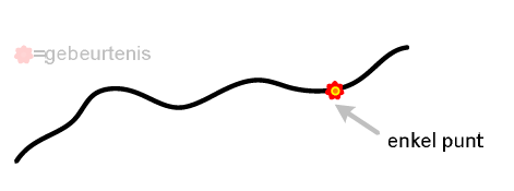
Point locations are encoded in DATEXII as coordinates of the exact position of the point location. The element locationForDisplay in v2.3 or pointByCoordinates in v3 is used for this.
Route Locations
DATEXII v3
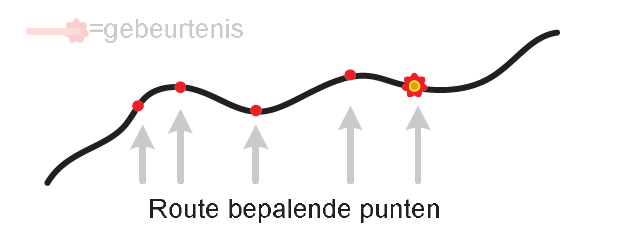
In DATEXII v3, the gmlLinestring in v3 should be used.
Optionally, coordinates can be included to best display the linear feature on a map in the element coordinatesForDisplay in v3.
DATEXII v2.3
Trajectlocaties worden in DATEXII v2.3 gecodeerd als coördinaten van de begin en eindpositie van het traject. Hiervoor wordt het element linearExtension in v2.3 gebruikt.
Optioneel is het opnemen van de coördinaten waarmee de Linear het beste op een kaart getoond kan worden opgenomen te worden in het element locationForDisplay in v2.3.
Area Locations
DATEXII v3
In DATEXII v3, either gmlMultiPolygon is used for this.
Additionally, coordinates in WGS84 format for geographic representation may always be included in the element coordinatesForDisplay in v3.
DATEXII v2.3
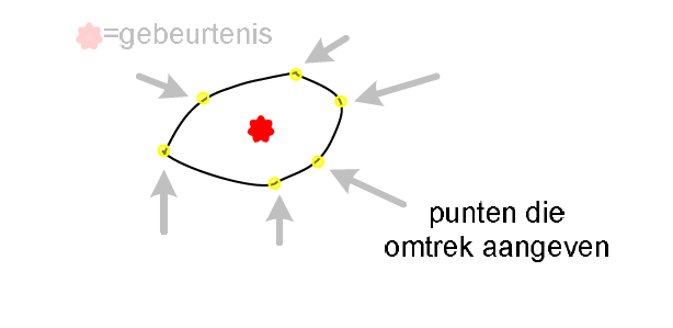
Area locations in DATEXII v2.3 are encoded as coordinates when the area has no VILD location available and the exact location can be accurately described using coordinates in the WGS84 format. This is done using a polygonArea within the areaExtension. A series of points is provided as an indication of the perimeter of the specified area.
Additionally, coordinates in WGS84 format for geographic representation may always be included in the element locationForDisplay in v2.3.
The polygon can be exactly described by including at least three coordinate pairs. Each coordinate pair is added as a separate element locationContainedInGroup of the type Point. At least the element pointByCoordinates for these elements will be populated. The set of coordinates represents points on the perimeter of an area or polygon. The order of the coordinates is arbitrary.